


We spent all day Saturday on a very long road trip. We set out to drive down the Natchez Trace from our house to Natchez, stopping along the way to have a picnic and take in some of the historic and scenic stops along the Trace. We did all this, but once we reached the outskirts of Natchez, instead of turning and heading toward home (via a faster route, the posted speed limit on the Trace is 50 MPH), we decided to go somewhere else. Tim was reminiscing as we drove into Natchez, that he used to drive this way to his last base when he was in the Air Force. That base was in Alexandria, LA and has since been decommissioned. I said something along the lines of “we should go there sometime for you to look around”, which Tim interpreted as “hey, let’s go there now!”. So, we took a several hour detour and also drove down to Alexandria so he could see what was left of the base and show me around his old stomping grounds. 
I took a lot (160+) of pictures on our day-long trip, and I’m trying to decide whether to post them all on Hambones. We made several stops along the way, including a couple of geocaching-related stops, as well as our picnic at Rocky Springs. I took lots of “scenic” pictures – pictures of churches, cemeteries, the old Trace, trees, historical markers, pre-Civil war buildings, etc. I’m going to post a few, along with the info, on the extended page, so check them out if you’d like. If you’d like to see them all, drop me a comment and I can load them all into Hambones.org.
OK, here we go….
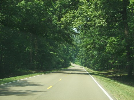
We started out heading south, and here’s a view of the Trace in the AM, very green and lush, and no cars on the road but us. It’s very pretty and scenic:
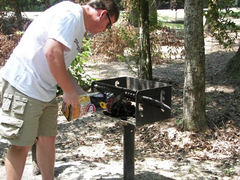
We stopped at Rocky Springs to grill our hot dogs and have lunch. Here’s Tim getting the fire going… we never use charcoal at home, we have a gas grill, so he had a good time making fire!
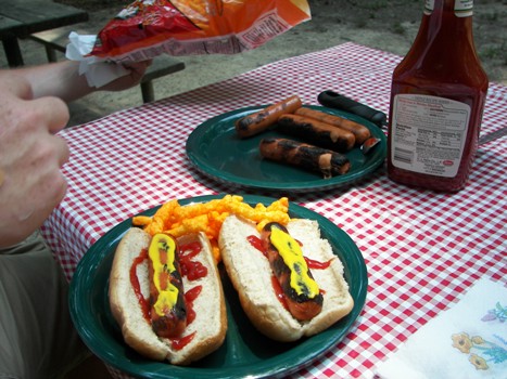
And the end result, hot dogs, potato chips, diet coke, fig newtons and fresh cherries:
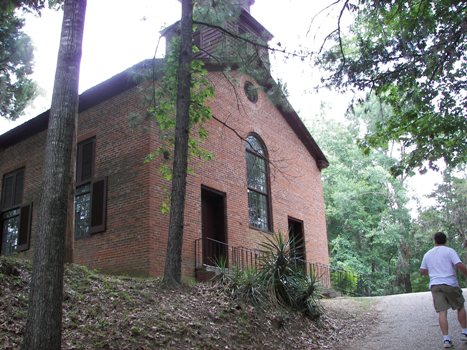
After lunch, we set out to find a geocache in the Rocky Springs area at a Methodist church that was built in 1837, and is still being used today. Using our GPS, we found the church, and both the church and adjoining cemetery were totally captivating to me. The trees were gorgeous, old and full of Spanish moss and silent memories. I took a lot of photos here, and we also found the geocache stashed nearby. Here’s the church:
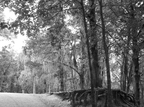
The trees beside the church were gorgeous and I was able to play with the settings on my still-new camera. I took this one in black and white mode, of the trees, exposed roots and all, with all this gorgeous Spanish moss hanging down from them:
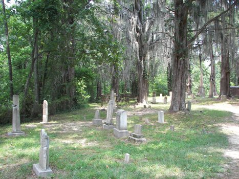
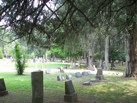
There is a cemetery behind the church, also dating back to the 1830’s. I took several photos in here, in black and white, sepia and regular color mode. There were some cool headstones, a very old crypt, more cool trees and other stuff that probably no one is interested in but me! I found one headstone that had the following engraved on it, and I loved the saying so much, I took a picture of it also! It said “Thus the human heart’s bereft, and nothing but memory is left”. Sigh.
We kept going south down the Trace, stopping at most of the historic and scenic stops. One of my favorite ones was a section of the original Natchez Trace that is called the “Sunken Trace”. You can actually get out and walk down a short section that is sunk way below ground. These huge trees have most of their roots eroded away now, and it makes for some really cool pictures. I am going to make a separate post with three of the photos I took here, of the same shot, in color, black and white, and sepia tones.
After the Sunken Trace and a couple of other stops, we decided to get off around Port Gibson and look for another geocache. We found another incredible cemetery, one of the oldest in Mississippi, which has a very large section of Confederate graves. We looked for a long time for the cache here, but never could find it. I also took a lot of pictures, as this was a huge cemetery, very picturesque and very beautiful:

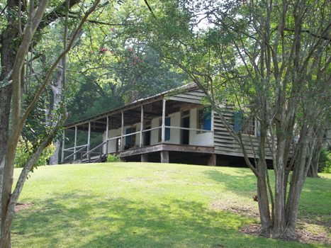
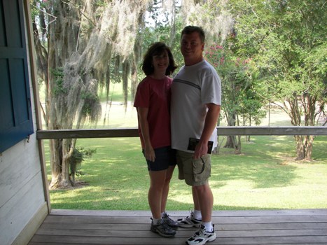
After admitting defeat that we couldn’t find the geocache, and getting back in the truck to get some air conditioning (wow, it was hot out there, searching for the cache in the mid 90 degree heat!), we got back on the Natchez Trace and drove on until we reached Mount Locust. Mount Locust was originally constructed circa 1780, and is the only remaining structure left along the Natchez Trace today that once served as an inn for travelers. In its life, Mount Locust was a working plantation as well as an inn. It has now been restored to what it looked like in 1810, as an overnight stop for travelers:
After touring Mount Locust, we drove on and eventually got to Emerald Mound just outside of Natchez. We had been here before on our previous trek, and I wanted to stop again. Emerald Mound is an Indian mound, a burial ground, and according to the marker, is the second largest temple mound in the United States (only one in Illinois is larger). It is an 8 acre mound and was built and used from around 1300 to 1600 by the local Mississippian Indians, ancestors to the Natchez Indians. It is hard to take pictures of, because of its size and breadth. You have to climb up a path to the first level, and then it looks several football fields in width. Then there is a set of stairs to climb to the top dome portion, which is where a ceremonial temple was housed. I took pictures, but I won’t post them here, as it’s hard to tell what is what!
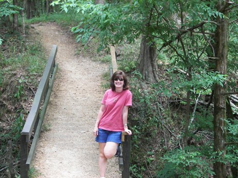
After the mound, we drove towards Natchez, and then eventually on to the former air base in Alexandria, and then home. It was a long day, but a good one. We didn’t have hardly any “people” pictures, I mostly took scenic pictures. But, I did hand my camera to Tim one time, and he took one of me, and there was a Park Ranger at Mount Locust that offered to take a picture of both of us. I’ll post those last, although by the time we got to Mount Locust, I was nearly a puddle of sweat from the heat, and it’s not a good picture of me. Ah well, c’est la vie!
These are great pictures! And it’s nice to see what you look like! That is especially a good photo of you and Tim. You look about 18 years old. You’re so cute! 🙂
Glad to read about your good trip. Jeff and I need to take off somewhere together soon…
very nice……..things I had never seen, myself. Good to do something different.
Next time you get a hankering to drive, drive up to see us !!
What great pictures! There is something that just makes the Trace amazing. I may suggest to Patt when we go to Utica next weekend for my newphew’s b’day for us to take the Trace there. The exit is only about 1 1/2 miles from my parents.
Thanks, I loved going down memory lane with your photo’s. Great to see what you look like!
Add A Comment